Contact Us
University of California Cooperative Extension Ventura County
669 County Square Drive, Suite 100
Ventura, CA 93003
Phone: 805.645.1451
Fax: 805.645.1474
Office Hours:
Monday - Friday from 9 a.m. to 4 p.m.
The office will be closed for the following holidays:
March 29 – Ceaser Chavez Day
May 27 – Memorial Day
June 19 – Juneteenth
July 4 - Independence Day
Additional facts about the area
contents
This section provides information about the general physiography of the Ventura Area, about the climate, and about the water supply and the means of supplying and distributing water in the Area. The Area has a varied physiography made up of a coastal plain, low mountains, and intermountain valleys. The climate, though on the whole mild and dry, varies because of the variations in physiography. Because the total amount of precipitation is small, conserving water and obtaining water from additional sources outside the Area are vital concerns.
Physiography
Part of the Ventura Area is on the Coastal Plain, and part is on the coastal mountains and in the intermountain valleys of the Transverse Range.
The Coastal Plain--About 85,000 acres of the survey Area, extending for 18 miles along the ocean and for about 9 miles inland, is on the Coastal Plain (4). The plain was formed by the deposition of sediments from the Santa Clara River and from the streams of the Calleguas-Conejo drainage system. It has a mean elevation of 50 feet, but at points south of the Santa Clara River, the elevation is as much as 150 feet, and at points north of the river, as much as 300 feet.
The part of the plain that extends south from the Santa Clara River to near Revolon Slough and centers on the city of Oxnard is known as the Oxnard Plain. The part that centers on the community of Camarillo is called Pleasant Valley; it is part of the Calleguas-Conejo drainage system.
Most of the arable land in the survey Area is on the Coastal Plain.
The coastal mountains--Mountains rim the Area on its landward side. They range in elevation from about 50 feet, along the coast south of the Coastal Plain, to about 3,100 feet, in the Santa Monica Mountains. The Santa Ynex Mountains, the Topatopa Mountains, and the Piru Mountains form the northern boundary, the Santa Susana Mountains the eastern boundary, and the Simi Hills and the Santa Monica Mountains the southern boundary. South Mountain and Oak Ridge are long, low, east-west mountains that separate Santa Clara Valley from Las Posas Valley and Simi Valley. The Camarillo Hills and the Las Posas Hills extend from Camarillo to Simi and separate the Las Posas-Simi area from Santa Rosa Valley and Tierra Rejada Valley.
The intermountain valleys--The valley of the Santa Clara River, the most prominent valley in the Area, trends east-southwest. The Santa Clara River drains an area of 1,605 square miles (5). It flows generally in a southwesterly direction from its head-waters in Los Angeles County to where it empties into the Pacific Ocean. Its principal tributaries are Sespe Creek, Piru Creek, and Santa Paula Creek. The mean seasonal natural runoff of the Santa Clara River at its mouth is estimated to be about 216,400 acre-feet (5).
The valley of the Ventura River is a rather marrow, north-south trending valley north of Ventura. Ojai Valley is connected to the Ventura River valley by San Antonio Creek. The small Upper Ojai Valley, east of Ojai Valley and 300 to 500 feet higher, drains to the Ventura River on the west and to Santa Paula Creek on the east. Ojai and Upper Ojai Val1ey are surrounded by mountains and are rich farming areas. The Ventura River flows generally south and drains an area of 226 square miles (5). The mean seasonal natural runoff of the river where it empties into the Pacific Ocean is estimated to be about 67,800 acre-feet (5).
Over South Mountain and Oak Ridge, south of the Santa Clara River, are Las Posas Valley and Simi Valley. Las Posas Valley extends eastward from the Coastal Plain almost to Simi Valley, which is in the east end of the Area. Simi Valley is bounded on the east by the Santa Susana Mountains and on the south by the Simi Hills. Old terraces occur around the perimeter of the Simi Valley. To the south, over the Camarillo Hills and the Las Posas Hills, are Santa Rosa and Tierra Rejada Valleys, which extend from Camarillo eastward for about 10 miles. In the hills south of Santa Rosa Valley is the high, broad Conejo Valley. Simi Valley, Santa Rosa Valley, Tierra Rejada Valley, and Conejo Valley are drained by Calleguas Creek and its principal tributary, Conejo Creek. These creeks originate in the Santa Susan and Santa Monica Mountains. They flow generally in a southwesterly direction and discharge into the Pacific Ocean through Mugu Lagoon. The drainage area is about 330 square miles in extent (5) . The mean seasonal natural runoff is estimated to be about 15,200 acre-feet (5).
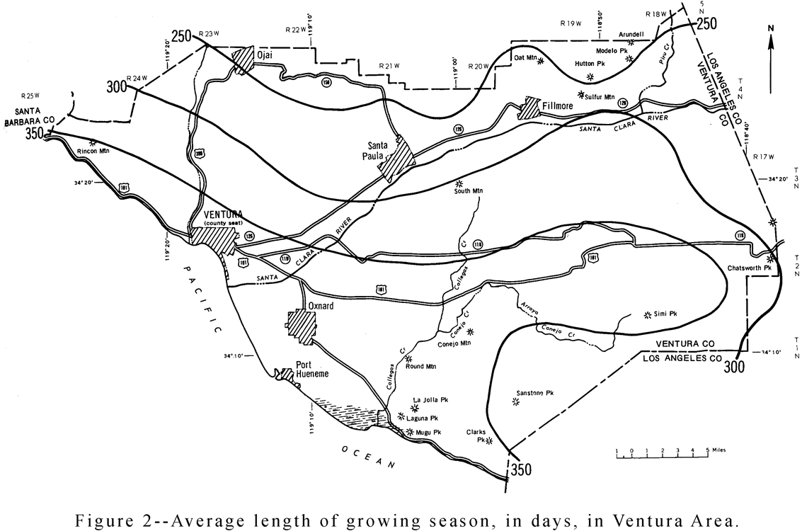
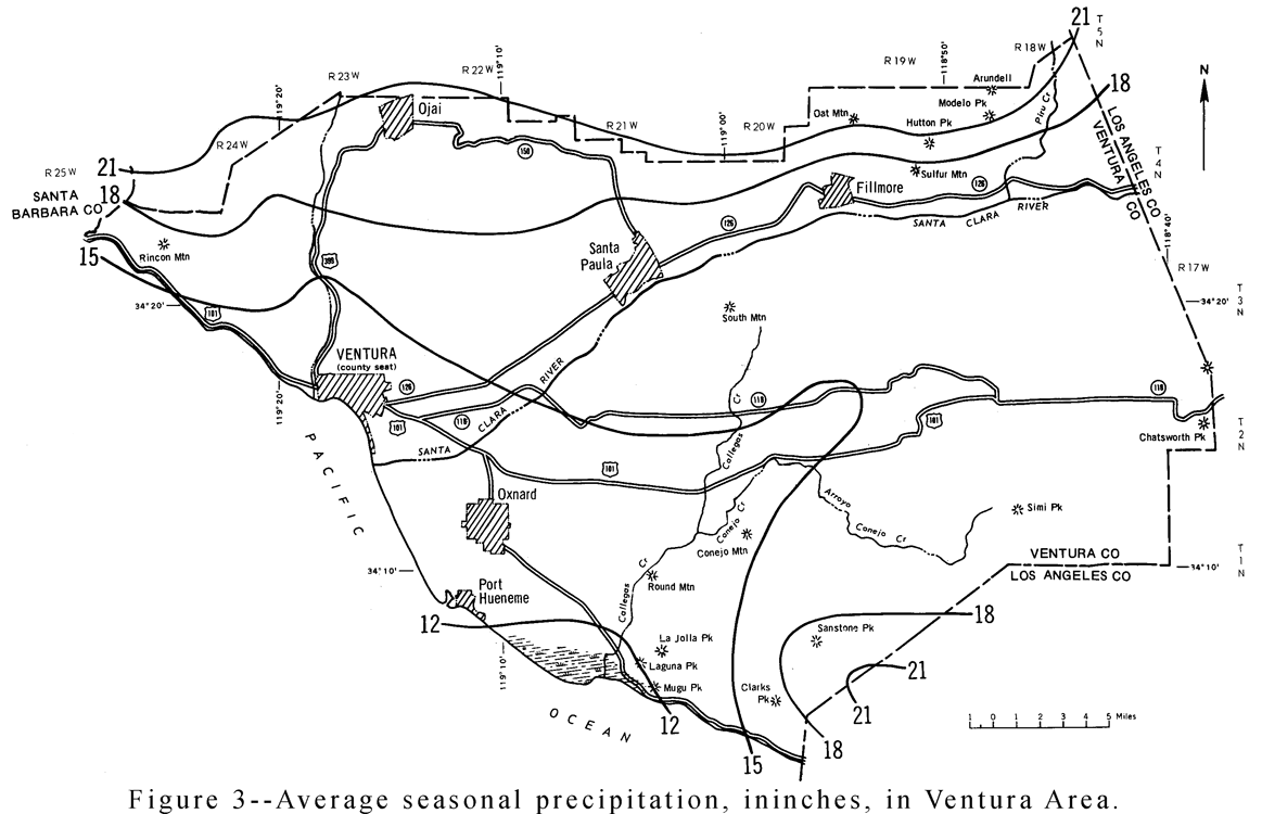
Climatic data for the whole of Ventura County are discussed in the text of this section, although only the southern half of the county was covered by this soil survey (see figure 1, page 1). Figure 2, Average length of growing season, and figure 3, Average seasonal precipitation, show only the part of the county that was surveyed.
Ventura County has a considerable range in climate because of differences in topography between one part of the county and another. In the survey area, temperatures are moderate and the growing season is long, but rainfall is limited in summer and crops have to be irrigated.
The average annual temperature is near 60 at low elevations near the coast, in the 50’s over most of the northern two-thirds of the county, and less than 45° in the Topatopa Mountains. The annual range in temperature is between 700 and 80° on the Coastal Plain and as much as 100° in the interior. For July, the average maximum temperature is between 70° and 80° on the Coastal Plain but exceeds 90° in the upper part of the Ventura and Cuyama River valleys. For January, the average minimum temperature is near 40° on the coast but in the 1ower 30’sandupper 20’s in the northern part of the county.
No temperature data are available for the highest parts of the county.
The average date of the last freeze (32° temperature) in spring is in .January near the coast and progressively later farther inland. In the northern half of the county, the average date is in May. In some locations near the coast, a freeze in fall is unusual .A little farther inland a freeze occurs, on the average in the latter part of December, and in the upper part of the Cuyama River valley, early in October. The length of the growing season ranges from more than 300 days near the coast (fig. 2) to less than 175 days in the coldest part of the county.
In both the northern and the southern ends of the county, the annual precipitation totals between 10 and 15 inches (fig .3). In the Topatopa Mountains, the annual total is more than 33 inches. The drier parts get less than 5 inches of rain in 1 year out of 20, and the higher, wetter parts get more than 60 inches in 1 year out of 20. Mesurable amounts of rainfall are reported on 30 to 35 days a year, and half an Inch or more on 6 to 12 days a year.
Over the northern half of the county, snowfall averages 5 inches or more a year, and along the northern border near Mt. Pinos, more than 20 inches
For the entire year, potential evapotranspiration ranges from about 30 inches near the const to 28 inches in the interior; for the growing season, it ranges from about 29 inches near the coast to about 20 inches in the interior. Estimated actual evapotranspiration for the year ranges from 12 inches in the southern part of the county to 7 inches in the northwestern corner; for the growing season, it ranges from 10 to 12 inches near the coast to only 3 to 5 inches near the Cuyama River. These figures suggest that range grasses are likely to dry out about June 1 near the cost, as early as May 20 in the northwest corner of the county, and as late as June 10 in the mountains.
Direct precipitation and runoff from tributary drainage areas are the principal sources of water in the survey Area. Small amounts of water are imported. Irrigation and urban needs are met mainly by pumping water from wells that draw from ground water storage basins. Since the 1930’s, consumption of water has exceeded replacement. Water conservation programs were initiated in the late 1940’s (3)
Water service is provided by individuals, by municipal and other public agencies, by many private agencies, and by public districts that deal with flood control and drainage problems as well as the problem of water supply.
Irrigation wells are generally owned by individuals, but there are mutual water companies that use a single well or a series of wells and distribute water on a share basis. Few individuals utilize surface water.
The three major water service agencies in Ventura County are the Calleguas Municipal Water District, the Ventura River Municipal Water District, and the United Water Conservation District.
The Calleguas Municipal Water District serves the southeastern part of the survey Area, which includes Simi Valley, the Thousand Oaks-Newbury Park area, and Camarillo. Well water and imported Colorado River water are used.
The Ventura River Municipal Water District serves the northwestern part of the surveyed Area, which includes the Ventura River Valley and Ojai Valley. The Robles Diversion Dam diverts water from the Ventura River through a canal into Casitas Reservoir, which has a capacity of 250,000 acre-feet. The district also maintains Matilija Reservoir, located northwest of Ojai on Matilija Creek, which has a storage capacity of 7,000 acre-feet.
The United Water Conservation District serves Santa Clara Valley and the Oxnard Plain. Water is supplied from both surface storage facilities and wells. Runoff from Piru Creek Is stored in the district‘s Lake Piru, which has a storage capacity of 100,000 acre-feet. Water is released from the lake for percolation into underground basins or for use as a surface supply. Ground water is utilized extensively on the Oxnard Plain. Aquifers underlying this area are recharged by operations at the District’s Piru, Saticoy, and El Rio spreading grounds.


