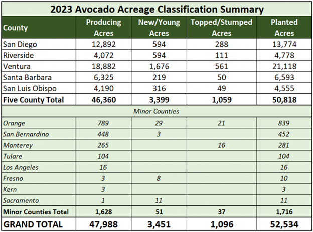
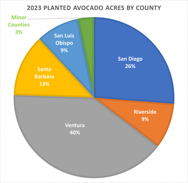
Each year the California Avocado Commission partners with Land IQ to produce a Statewide Avocado Acreage and Condition Analysis report utilizing digital satellite imagery, aerial photography and analytical tools to survey California avocado groves. This data helps the Commission make informed budgeting and marketing decisions and provides industry members with spatial data concerning crop type, location, condition and density. See the full 2023 Report HERE.
According to the report:
- In 2023 there were 52,534 planted avocado acres
- The majority of growing acreage is located in Ventura, San Diego, Santa Barbara, Riverside and San Luis Obispo Counties with a total of 50,818 planted acres
- The five top-producing counties reported 1,059 new/young acres and 3,399 topped/stumped acres
The report also provides acreage data by zip code, county, condition, year planted and density.
The California Avocado Commission's crop estimating team in conjunction with Land IQ uses the latest in remote sensing techniques to assess avocado acreage in production. As technology continues to advance refinements in our fourth generation of remote sensing techniques were applied to satellite imagery collected during spring and summer months. The imagery processing techniques include; segmentation into homogenous polygons, retention of tree crop polygons, calculation of average crop canopy moisture and vegetation indices, analysis of change maps from previous inventories, and classification of avocado groves into four categories; producing, topped/stumped, new/young, and abandoned. Aerial imagery (for a real-world view), and satellite imagery (for spectral and temporal data) are integrated into previously classified avocado acreage and analyzed for current condition of California avocado acreage statewide.
from CA Ag Net: https://californiaagnet.com/2024/07/29/california-avocado-acreage-increases-2023-report-available/


