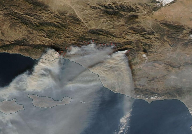
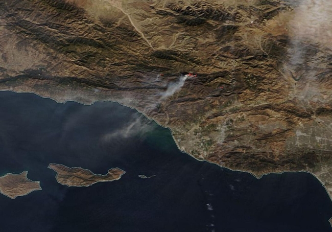
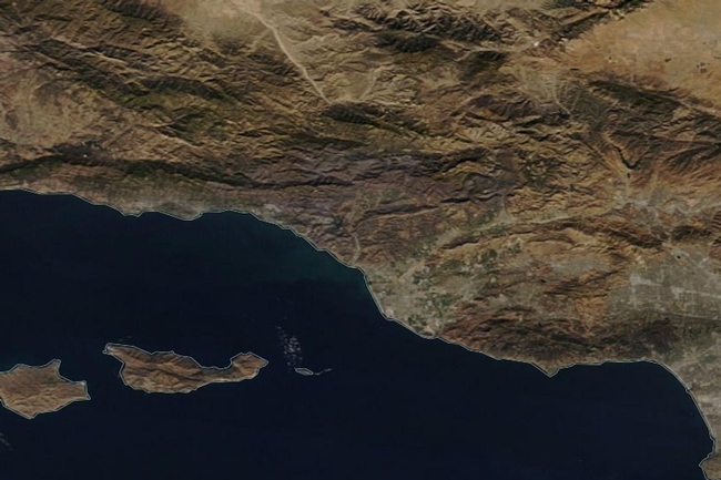
What a difference a few days can make in the life cycle of a fire. In this particular case, the Thomas Fire that is ongoing in the Ventura County around (and surrounding) in Southern California. The following images were taken by the Terra and Aqua satellites on Dec. 16, 17, and 19, 2017, and during those times fire conditions improved visibly. A difference in winds, in humidity, in the ability of firefighters to control the fire's perimeter, and in the amount of fuel left for the fire to consume can bring a raging fire to heel. This does not mean the fire cannot gain strength again if conditions worsen, but it is heartening to realize that weather conditions can allow firefighters to get a better handle on events as they have in the last few days.
This the the Thomas Fire on December 16, 2017 as seen by the Terra satellite. There were multiple areas of "hot spots" where the satellite indicates the fire is and where telltale smoke also pinpoints fire spots. These areas are numerous and the clouds of smoke coming off the flames are all consuming.
By December 17, 2017, conditions had obviously changed for the better and the fires were able to be somewhat contained. This image taken by the Aqua satellite on December 17, 2017, shows a much more subdued Thomas Fire. There are still hot spots visible but the number has vastly improved.
By December 19, 2017, hot spots are not showing up via satellite instruments. This does not mean the fire is completely out, but large hot spots are no longer detected by satellites. So, too, the copious smoke that was spewing from the fires is no longer in evidence. This Aqua image shows a much calmer landscape due to improving weather conditions at the time.
Per Inciweb today, the Thomas fire is 60 percent contained at present. At 272,000 acres, the Thomas Fire is now the second largest fire in the recorded history of the state of California. Unfortunately, weather conditions that allowed the fire to be contained to the 60 percent mark are destined to change as weather conditions deteriorate this afternoon. Inciweb reports that a forecasted strong north wind event will bring wind conditions similar to those experienced when the fire made its push into Montecito. With the introduction of these winds, critically dry fuels will be highly receptive to fire spread. During Santa Ana wind events three things happen: the weather warms, winds pick up, and humidity drops precipitously. All of these events promote fire growth. The Thomas Fire has experienced winds exceeding 70 miles per hour, temperatures in the mid 80's and humidity below 10 percent.
###
NASA image courtesy NASA Worldview application operated by the NASA/Goddard Space Flight Center Earth Science Data and Information System (ESDIS) project. Caption by Lynn Jenner with information from Inciweb.


