Posts Tagged: roadkill
Reducing roadkill on freeways

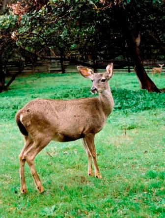
UC Davis researchers and state Department of Fish and Game officials are capturing deer between Dec. 2 and Dec. 15 along a stretch of the freeway from Millbrae to Woodside, said Fraser Shilling (video clip), head of the research project and co-director of the Road Ecology Center at UC Davis.
Using tranquilizer darts fired from a rifle, or "clover traps" (large netting enclosures), about 15 deer are expected to be captured. Researchers plan to capture another 30 deer by the time the project is completed in May 2013.
The deer would be "minimally disturbed" by the darts or enclosures, with the worst harm being from falling down, according to Shilling.
"That's the level of harm," he said. "There's no long-term damage to it."
The captured deer will be fitted with GPS collars that will record their location and send the information to researchers who will use the data to track the deer as they move along the areas adjoining the freeway, or onto the roadway itself.
Timers will automatically release the collars after six months, Shilling said.
Besides tracking the deer, researchers will also use 40 wildlife cameras to capture images of wildlife and map the locations of road kill. The information will be used to make a recommendation to determine what kind of strategies could be used to reduce the number of collisions between deer and other animals on the freeway.
Deer grazing along the side of the freeway and dead deer on the shoulder are common sights along the roadway, which runs through mostly heavily-wooded areas, rolling hills, and grasslands between San Francisco and San Jose.
The deer study, funded by a $320,000 grant through the federal Transportation Enhancement program, will be used to try to reduce the number of collisions between cars and deer on the freeway.
Every year, about 300,000 collisions occur nationwide between vehicles and wildlife, resulting in 200 deaths and 26,000 injuries. The costs associated with deer strikes alone add up to $8.5 billion annually.
Road Ecology Center at UC Davis
“Road ecology” is emerging as an environmental science focusing on the impact of roads on nature, such as how plant and animal populations are fragmented by roads, and how vehicle noise and pollution negatively impact animals and plants.
An understanding of road ecology also allows transportation planners to optimize mobility while minimizing the adverse impact of roads and vehicles.
The UC Davis Road Ecology Center brings together policy makers from transportation and environmental settings to design sustainable transportation systems that complement the needs of natural landscapes and human communities.
Some of the organizations partnering with the Road Ecology Center on projects include Caltrans, the California Department of Fish and Game, the UC Davis Sustainable Transportation Center, the John Muir Institute of the Environment and the Institute of Transportation Studies at UC Davis, and Defenders of Wildlife.
Citizen science
A “citizen science” component of the Road Ecology Center is the California Roadkill Observation System, a statewide roadkill reporting website for people to record their observations of dead animals and their environmental context. The information will be used to reduce the number of roadkill incidents.
The top 5 species of animals killed on California roads and highways are raccoon, striped skunk, California ground squirrel, Virginia opossum, and mule deer (or black-tailed deer).
Want to report SOD? We’ve got an app for that!
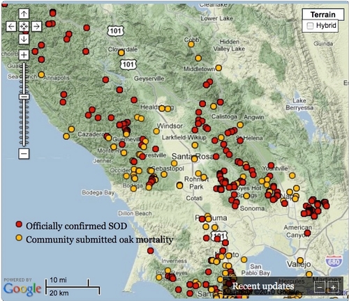
When the great outdoors is your research laboratory, gathering data can be a challenge. To get a broader perspective on the extent of damage caused by sudden oak death, a UC Berkeley Cooperative Extension geographer is using crowd sourcing to enhance her research on the disease that has killed over a million of California’s iconic oak trees since 1995.
Maggi Kelly, UC Berkeley Cooperative Extension specialist, started collecting data from community members through her OakMapper website in 2001. Now she has a mobile application for smartphones

While out in a park or forest, iPhone users can use the new OakMapper mobile app to report sightings of trees killed by Phytophthora ramorum, the plant pathogen that causes SOD. Onsite, participants can note the symptoms they see, such as seeping, bark discoloration, crown discoloration, dead leaves, shoot die-back, fungus, beetle frass and beetle bore holes.
The OakMapper app, created by scientists in the UC Berkeley Geospatial Innovation Facility, uses the phone's built-in GPS to identify the participant’s location when the data is submitted.
They also can describe the environmental setting, such as residential landscape or natural forest.
“Many of the challenging natural resource problems that we face today – like invasive species, fire, climate change – are large in spatial scale and impact diverse public groups,” said Kelly, director of the UC Berkeley Geospatial Innovation Facility. “Addressing these challenges often requires coordinated monitoring, efficient data collection, and increased communication and cooperation between scientists and citizens.
Science can benefit from your powers of observation. We all benefit by becoming informed about problems such as sudden oak death.
If you are like me, a person who sometimes doesn’t recognize coworkers outside the office, you may choose a spectator role. You can use the app to look at the maps to see where SOD is taking down trees.
For more information about OakMapper and its app, visit oakmapper.org. The OakMapper app can be downloaded for free from the iTunes app store.

I’ve heard of two other apps developed at UC to collect natural resources-related data from other scientists and interested members of the public.
You can use UCLA’s What’s Invasive apps to report locations of top invasive plants and animals, which compete with California’s native fauna and flora. By submitting location data and setting up top invasive lists for your area, you can assist scientists monitoring the spread of the destructive invasive plants and animals. Images and brief descriptions in the app help with identification. The apps are free and available for the Android and iPhone.
Soon you will be able to report roadkill sightings on your iPhone. The UC Davis Road Ecology Center has submitted to the iTunes store an iPhone app for reporting roadkill. Until the app becomes available sometime in January, you can report your observations to the California Roadkill Observation System via the Web at http://roadecology.ucdavis.edu/CROS.html.
Another cool app has been developed by the UC Davis Soil Resource Laboratory to deliver information to scientists, growers and gardeners about the properties of their soil. While standing in the field, the user can receive location-based information on a GPS-enabled cell phone. The app is available for free for iPhone and Android OS platforms.
Which science-related apps are you using? You can share them in the comments section or e-mail me at pskanrice@ucdavis.edu.
