

Posts Tagged: soil
Know Your Dirt
I am frequently asked if I can recommend a book on Soils. And yes, I can. It is Soils: An Introduction by Michael Singer and Donald Munns. The sixth edition recently came out so there's a lot of older used copies floating around on the wed for under $10. This book takes a different tack on describing soils. Instead of tacking the tack of a chapter on Nitrogen another on Calcium etc., it weaves a story of how all the parts are related.
Soil Biodiversity Report
CDFA has released a report on Belowground Biodiversity which provides targeted recommendations for policymakers and stakeholders to enhance soil health and conserve biodiversity, which plays an important role in climate resilience and food production.
An advisory committee of soil scientists authored the report, led by Dr. Kate Scow, Distinguished Professor Emeritus of Soil Science and Microbial Ecology at UC Davis: Dr. Eoin Brodie, Deputy Director of the Climate and Ecosystem Sciences Division at Lawrence Berkeley National Laboratory; and Dr. Margaret Smither-Kopperl, Manager, Lockeford Plant Materials Center, United States (US) Department of Agriculture, Natural Resources Conservation Service..
“The State of California contains more than 2,500 types of soil – they host a wealth of life that makes vital contributions to the global food supply,” said Dr. Scow. “Improved understanding of belowground biodiversity is essential to achieving a carbon-neutral future and tackling climate change.”
The report provides recommendations including using soil biodiversity as a key metric for assessing and prioritizing soil health and multi-functionality, integrating a soil biodiversity assessment into CDFA's Healthy Soils Program, and developing an adaptive management framework that incorporates soil biodiversity assessment.
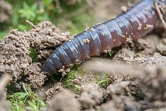
wormns and birds
Soil Health?
Soil health refers to the ability of a specific soil to perform multiple functions, including nutrient cycling, sustaining plant and animal growth, maintaining diversity, regulating water dynamics, moderating climate and a whole slew of other attributes we expect of soils. An assessment needs to approach the biological, chemical and physical properties of the soil and how they interact. It's been difficult to create a one-size fits all evaluation process of assessment. Sometimes it might be just as easy to smell it or look at how plants are growing in it to give it a rating, but these measures can be very subjective across noses and viewpoints. The USDA's Natural Resource Conservation Service has developed a field methodology that attempts to standardize some of the physical and biological parameters. The in-field assessment comes in both a short and long form. Check them out – Cropland In-Field Soil Health Assessment Guide:
Short version
https://directives.sc.egov.usda.gov/OpenNonWebContent.aspx?content=44419.wba
Long version

soil layers
Find YOUR Soil
Soils vary across a landscape according to soil-forming factors present in a particular location. To help those involved in land management and planning, the U.S. Department of Agriculture launched the National Soil Survey in 1899 to systematically map changes in soils across the country. Results were originally organized by county, and the mapping results published in county soil surveys.While the paper surveys were useful, one had to use several maps at different scales to locate the soil-map units for a site-specific location, then cross-reference the mapping unit to tables provided in the survey to obtain information on soil properties. Today, county soil survey information has been converted to a digital format known as the Web Soil Survey (WSS), which is accessible to the public via the Internet. The WSS provides the USDA's official soil survey data and information in a digital format. The tool was developed and is maintained by the USDA's Natural Resources Conservation Service (NRCS). Information in WSS is generated from the National Cooperative Soil Survey conducted by NRCS. The WSS can provide user-defined, site-specific information on soil properties that can be useful for agricultural producers, conservation professionals, scientists and others.
It is important to note that the accuracy of WSS is determined by the scale of the soil map. Most soil surveys are conducted at a scale of 1:20,000; reading soil data and maps should be performed at the same scale to ensure accuracy. A major advantage of WSS over the original paper surveys is that data can be extracted in digital formats, which can be imported directly into a geographic information system (GIS). The information can thenbe spatially aligned with other digital information, such as maps, satellite imagery, photo- graphs, and user-specified geographic coordinates obtained from global positioning systems, or GPS. This allows land-resource managers to efficiently aggregate information tailored to a specific purpose or location. For example, agricultural producers can overlay crop yield maps created with yield monitors with WSS information to determine how different soils may affect crop production
https://websoilsurvey.sc.egov.usda.gov/App/HomePage.htm
Web Soil Survey (WSS) provides soil data and information produced by the National Cooperative Soil Survey. It is operated by the USDA Natural Resources Conservation Service (NRCS) and provides access to the largest natural resource information system in the world. NRCS has soil maps and data available online for more than 95 percent of the nation's counties and anticipates having 100 percent in the near future. The site is updated and maintained online as the single authoritative source of soil survey information.
Soil surveys can be used for general farm, local, and wider area planning. Onsite investigation is needed in some cases, such as soil quality assessments and certain conservation and engineering applications. For more detailed information, contact your local USDA Service Center at the following link: USDA Service Center or your NRCS State Soil Scientist at the following link: NRCS State Soil Scientist.
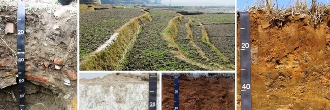
soil heading pictures
Soil Taxonomy Keys
|
Keys to Soil Taxonomy, Thirteenth Edition (5.14 MB) Online version
The Keys to Soil Taxonomy provides the taxonomic keys necessary for the classification of soils in a form that can be used easily in the field. It also acquaints users of soil taxonomy with recent changes in the classification system.
Recommended Citation
Soil Survey Staff. 2022. Keys to Soil Taxonomy, 13th ed. USDA-Natural Resources Conservation Service.
Illustrated Guide to Soil Taxonomy
Illustrated Guide to Soil Taxonomy, version 2.0 (21.62 MB)
The Illustrated Guide to Soil Taxonomy was produced for use by multiple audiences and is not intended to replace the full version of the Keys to Soil Taxonomy for the professional soil classifier. Some of the more technical and complicated criteria have been omitted or referenced in notes to make the user aware that there are exceptions. More complete criteria and definitions are available in the full version of the Keys to Soil Taxonomy.
This edition of the illustrated guide (version 2.0) is based upon the twelfth edition of the Keys to Soil Taxonomy.
When using the illustrated guide, open the bookmarks tab on the left side of the screen in Adobe Acrobat to navigate the document.
Recommended Citation
Soil Survey Staff. 2015. Illustrated guide to soil taxonomy. U.S. Department of Agriculture, Natural Resources Conservation Service, National Soil Survey Center, Lincoln, Nebraska.
Keys to Soil Taxonomy, Spanish Version
Claves para la Taxonomía de Suelos, Décima segunda Edición, 2014 (5.41 MB) online
For decades, NRCS has worked with soil scientists from around the world to increase awareness and expand knowledge of the importance of soil and its impact on all aspects of life. The translation expands the horizons of the Keys to Soil Taxonomy by allowing professionals around the world to apply and interpret the system in a more uniform and consistent way. While soils differ globally, the ability to apply a system that is universally understood and accepted is a goal shared by many soil scientists.
As the world struggles with global warming and other environmental challenges, having a universally accepted method that can be applied when soil problems are addressed will contribute to successful outcomes. Soil scientists and other professionals from Latin America, the United States, and other countries will benefit from this translation effort for years to come.
The translation of the “Keys” into Spanish was performed by Carlos Alberto Ortiz-Solorio, Ma del Carmen Gutiérrez-Castorena, and Edgar V. Gutiérrez-Castorena of Área de Génesis, Morfología y Clasificación de Suelos, Programa de Edafología, Campus Montecillo, Colegio de Postgraduados en Ciencias Agrícolas.
Recommended Citation
Soil Survey Staff. 2014. Claves para la Taxonomía de Suelos, 12th ed. USDA-Natural Resources Conservation Service, Washington, DC.
Ordering Keys to Soil Taxonomy
A printed copy is available from:
NRCS Distribution Center
Enter keywords: keys to soil taxonomy
Phone: 888-526-3227
E-mail: NRCSDistributionCenter@ia.usda.gov

soil heading pictures
